Northeast Monsoon Watch 2026
Tamil Nadu, Chennai and the Evolving Bay of Bengal
Understanding the science, tracking the atmospheric signals, and analysing the rainfall outlook for October–December 2026
Published: 17 October 2026 | By Vijay Alagarsamy
Weather • Climate • Earth Science • Data Analysis
When the Monsoon Returns to Tamil Nadu
For much of India, the arrival of the Southwest Monsoon (SWM) marks the beginning of the principal rainy season. Farmers prepare their fields, rivers begin to replenish, reservoirs receive fresh inflows, and millions of people eagerly await the first monsoon showers.
But Tamil Nadu has a different monsoon story.
When the Southwest Monsoon begins to withdraw from the Indian subcontinent during September and October, much of the country gradually moves towards relatively drier weather.
Meanwhile, Tamil Nadu, particularly its eastern coastal regions, prepares for one of its most important rainfall periods of the year — the Northeast Monsoon (NEM), locally known as Vadakizhakku Paruvamazhai (வடகிழக்குப் பருவமழை).
Unlike the Southwest Monsoon, which dominates India's rainfall between June and September, the Northeast Monsoon generally occurs during October, November and December.
For Tamil Nadu, Puducherry and Karaikal, this three-month period contributes approximately 48% of the annual rainfall, making it critical for agriculture, groundwater recharge, water storage, ecosystems and the daily lives of millions of people.
Chennai, situated along the Coromandel Coast, is even more dependent on this seasonal rainfall.
As someone who enjoys observing and understanding weather systems, I have always been fascinated by the interaction between our oceans and atmosphere.
What makes a circulation develop over the Bay of Bengal? Why do some low-pressure systems intensify rapidly while others weaken? Why does one weather system bring widespread rainfall across Tamil Nadu while another produces intense rainfall over a few coastal districts?
And perhaps the most interesting question:
How can changes occurring thousands of kilometres away in the Pacific and Indian Oceans influence rainfall over Chennai?
These questions form the basis of my continuing interest in meteorological observations, satellite imagery, numerical weather prediction and large-scale climate phenomena.
Over the years, I have documented several weather developments, including cyclonic disturbances, Northeast Monsoon seasons, tropical systems and extreme rainfall episodes.
This blog continues that exploration, with a specific focus on Northeast Monsoon 2026.
Why Is Northeast Monsoon 2026 Particularly Interesting?
The 2026 season is developing against an unusual and evolving global climate background.
A strong El Niño is underway in the equatorial Pacific Ocean.
The Indian Ocean Dipole is displaying positive weekly index values, although the event has not yet been formally established as a positive IOD.
Meanwhile, the Madden–Julian Oscillation, sea-surface temperature patterns and tropical atmospheric circulation may influence how rainfall develops over the Indian Ocean and Bay of Bengal in the coming weeks.
The India Meteorological Department (IMD) has forecast normal seasonal rainfall over South Peninsular India for October–December 2026.
However, the numerical weather prediction charts from ECMWF, EC-AIFS and GFS present several interesting possibilities involving evolving circulation systems over southern India, the Arabian Sea and the Bay of Bengal.
Importantly, the NEM officially commenced on 15 October 2026, approximately five days ahead of its normal onset date.
The atmosphere has already begun its seasonal transition.
But will the early onset translate into a wetter-than-normal season?
Could a strong El Niño contribute to enhanced Northeast Monsoon rainfall?
Will low-pressure systems develop over the Bay of Bengal during late October and November?
And what could these developments mean for Tamil Nadu and Chennai?
These are the questions I intend to explore throughout NEM 2026.
What This Blog Covers
This blog is organised into two main sections.
Section 1 — Understanding the Northeast Monsoon
An exploration of the science behind the Northeast Monsoon, including atmospheric circulation, seasonal wind reversal, geographical influences, the Bay of Bengal, cyclogenesis and the interaction of important global climate indicators such as ENSO, IOD and MJO.
Section 2 — Northeast Monsoon 2026: Observations, Model Analysis and Rainfall Outlook
A developing record of the 2026 season, combining official IMD observations, seasonal forecasts, satellite and weather-model interpretations, and possible implications for Tamil Nadu and Chennai.
Rather than focusing only on daily rainfall predictions, the objective is to understand the atmospheric processes responsible for those predictions.
Numerical weather models do not always agree, and their forecasts can change substantially, especially beyond a week.
Therefore, the analysis will distinguish between confirmed meteorological observations, official forecasts and my own interpretations of the available information.
The intention is not merely to predict whether it will rain tomorrow.
It is to understand why the atmosphere behaves the way it does — and how that behaviour eventually influences the places where we live.
This article will be updated as significant meteorological developments occur during Northeast Monsoon 2026.
Section 1
Understanding the Northeast Monsoon
What Is the Northeast Monsoon?
The Northeast Monsoon is a seasonal atmospheric circulation system that brings significant rainfall to southeastern peninsular India, particularly during October, November and December.
It is also referred to as the retreating monsoon or winter monsoon, although the Northeast Monsoon is not simply a continuation of Southwest Monsoon withdrawal. It has its own characteristic wind patterns, moisture transport mechanisms and rain-producing systems.
During the Southwest Monsoon, prevailing winds over much of India are predominantly southwesterly.
As the season progresses towards October, changes in the thermal and pressure distribution over the Indian landmass and surrounding oceans contribute to a gradual reorganisation of the atmospheric circulation.
The monsoon trough retreats, lower-tropospheric winds begin to change direction, and easterly or northeasterly winds become established over southern peninsular India and adjoining parts of the Bay of Bengal.
Although winds originating from the continental northeast can be comparatively dry, their movement across the Bay of Bengal allows them to acquire substantial moisture through evaporation.
When favourable atmospheric conditions develop, this moisture can subsequently produce significant rainfall over Tamil Nadu and neighbouring regions.
The Northeast Monsoon affects five major meteorological subdivisions:
Tamil Nadu, Puducherry and Karaikal
Coastal Andhra Pradesh and Yanam
Rayalaseema
Kerala and Mahe
South Interior Karnataka
Its rainfall contribution is particularly important for Tamil Nadu because of the geographical position of the state and its relationship with the Western Ghats.
Why Does Tamil Nadu Receive More Rain During the Northeast Monsoon?
The Western Ghats play a major role in shaping the rainfall distribution over peninsular India.
During the Southwest Monsoon, moisture-bearing winds from the Arabian Sea encounter the Western Ghats.
As these winds rise along the western slopes, the air cools, moisture condenses, and substantial orographic rainfall occurs over the windward side of the mountain range.
Consequently, much of Kerala and the western coastal belt receives abundant rainfall.
As the air descends towards the eastern side of the Western Ghats, rainfall generally decreases, producing a rain-shadow effect across significant portions of Tamil Nadu.
However, during the Northeast Monsoon, the prevailing low-level wind pattern changes.
Moisture-bearing winds from the Bay of Bengal can approach the southeastern coast of India more directly.
This makes Tamil Nadu's eastern coastal districts particularly receptive to rainfall associated with easterly waves, troughs, cyclonic circulations and low-pressure systems.
The coastal districts do not necessarily receive equal rainfall.
The direction of the incoming winds, location of atmospheric convergence, movement of weather systems, local topography and prevailing atmospheric instability determine where rain develops and how intense it becomes.
This is why the Northeast Monsoon can produce considerable spatial variation even within Tamil Nadu.
How important is the Northeast Monsoon to Tamil Nadu?
According to the IMD's regional climatological records, the Tamil Nadu–Puducherry–Karaikal meteorological subdivision has an annual rainfall normal of approximately 921.4 mm.
Of this, the October–December Northeast Monsoon contributes around 442.8 mm, or approximately 48%.
Thus, nearly half of the annual rainfall occurs during a three-month period.
In contrast, the wider South Peninsular India region receives approximately 30% of its annual rainfall during the Northeast Monsoon season.
This difference highlights why the seasonal performance of NEM is particularly important for Tamil Nadu.
Suggested Figure 1: Southwest Monsoon versus Northeast Monsoon wind directions, showing the Western Ghats, Bay of Bengal and Tamil Nadu.
Why Is Chennai Particularly Dependent on the Northeast Monsoon?
Chennai lies along the Coromandel Coast, adjacent to the western Bay of Bengal.
Its geographical location makes it highly sensitive to moisture transport from the east and northeast.
According to the IMD's 1991–2020 climatological records for Chennai's Nungambakkam observatory, the normal monthly rainfall is:
October300.3 mm - November 373.6 mm - December 182.4 mm | October–December total 856.3 mm | Annual total 1,376.8 mm
Approximately 62% of Chennai's annual rainfall occurs during October–December, based on these station normals.
This is substantially higher than Tamil Nadu's broader subdivisional contribution of approximately 48%.
November is climatologically Chennai's wettest month.
However, these figures describe long-term averages at Nungambakkam, not rainfall guaranteed in every neighbourhood or every year.
Actual rainfall can vary considerably depending on the number, strength and tracks of individual weather systems.
A single intense rainfall episode may account for a significant proportion of a month's precipitation.
Why can Chennai experience intense rainfall during the night?
During active Northeast Monsoon conditions, favourable interactions between incoming marine moisture, coastal convergence, atmospheric instability and mesoscale circulations can promote rainfall development overnight or during the early morning.
Coastal land-breeze and sea-breeze circulations may also influence the timing and location of convection, depending on the larger-scale wind pattern.
However, nighttime rainfall is not an automatic feature of every Northeast Monsoon system.
The timing depends on the structure and movement of the rain-bearing clouds and prevailing atmospheric conditions.
The Bay of Bengal — A Major Moisture Source
The Bay of Bengal plays an exceptionally important role in the Northeast Monsoon.
It provides moisture to rain-producing weather systems and serves as an important region for the development of tropical disturbances.
Sea-surface temperature, evaporation, low-level winds, atmospheric humidity, moisture convergence, vertical instability and upper-level circulation all influence how weather systems develop.
A warm ocean surface can increase evaporation and support the availability of moisture in the lower atmosphere.
However, moisture availability alone is insufficient to produce intense rainfall.
Air must also be lifted so that cooling and condensation can occur.
This lifting may be associated with atmospheric convergence, troughs, cyclonic circulations, terrain, frontal boundaries or convective instability.
When large quantities of moisture are transported towards a region and converge within the atmosphere, organised cloud systems can develop.
For coastal Tamil Nadu, the direction and persistence of moisture transport from the Bay of Bengal are particularly important.
Why does the location of a Bay of Bengal system matter?
Consider two hypothetical situations.
Scenario A: A low-pressure system develops over the southwest Bay of Bengal and moves towards the Tamil Nadu coast.
If it maintains favourable moisture transport and organised rainbands, rainfall over Tamil Nadu could increase substantially.
Scenario B: A stronger system develops over the northern Bay of Bengal and tracks towards Bangladesh or the northern Indian coast.
Although it may be more intense, its direct rainfall impact over Tamil Nadu could be comparatively limited.
This demonstrates an important principle:
The intensity of a low-pressure system alone does not determine how much rainfall Chennai will receive. Its location, movement, structure and surrounding atmospheric circulation are equally important.
Understanding Troughs, Cyclonic Circulations and Low-Pressure Systems
Meteorological bulletins frequently use terms such as trough, upper-air cyclonic circulation, low-pressure area, depression and cyclonic storm.
Although these terms are related, they do not describe the same atmospheric phenomenon.
Trough
A trough is an elongated region of relatively low atmospheric pressure or lower geopotential height.
Troughs can support convergence and rising air, depending on their structure and surrounding wind patterns.
A trough does not necessarily have a closed circulation.
Upper-Air Cyclonic Circulation
An upper-air cyclonic circulation is a rotating atmospheric flow identified at a particular altitude or pressure level.
In the Northern Hemisphere, cyclonic circulation is generally anticlockwise.
Such systems can influence atmospheric instability and rainfall, but they do not necessarily have an associated closed low-pressure centre at the surface.
Low-Pressure Area (LPA)
A low-pressure area is a region where surface atmospheric pressure is relatively low compared with surrounding areas.
It may contain organised cyclonic circulation and associated rainfall activity.
An LPA can strengthen, remain weak or dissipate depending on environmental conditions.
Depression and Deep Depression
When a tropical disturbance develops a sufficiently organised circulation and reaches the designated sustained wind-speed thresholds, it can be classified as a depression or deep depression under IMD criteria.
Cyclonic Storm
A cyclonic storm is a more intense organised tropical system, with maximum sustained surface winds of at least 34 knots under the classification used for the North Indian Ocean.
Importantly, storm classification depends on characteristics including maximum sustained winds and system organisation.
A model depicting a mean sea-level pressure centre of 1000 hPa or 980 hPa does not, by itself, confirm that an actual cyclone will develop.
Can a weak system produce heavy rainfall?
Yes. A relatively weak but slow-moving weather system may produce substantial rainfall if it maintains persistent moisture convergence and repeated rainbands over the same region.
Conversely, a powerful cyclone passing far offshore may produce less rainfall over a particular city. Thus, rainfall impact and cyclone intensity must be considered separately.
El Niño, La Niña and Their Influence on NEM
The El Niño–Southern Oscillation (ENSO) is one of the most important drivers of interannual climate variability across the tropical Pacific.
ENSO comprises three broad states:
El Niño — unusually warm conditions in the central and eastern equatorial Pacific, together with associated atmospheric changes.
La Niña — unusually cool conditions in those regions, together with associated atmospheric changes.
ENSO-neutral — neither El Niño nor La Niña conditions are established.
ENSO can influence atmospheric circulation thousands of kilometres away from the tropical Pacific through a process known as teleconnection.
How does ENSO influence Indian rainfall?
During the Southwest Monsoon, El Niño has historically been associated with an increased tendency towards deficient rainfall over India, although the relationship is not absolute.
However, Northeast Monsoon rainfall over southeastern India frequently displays a different relationship.
Several studies have identified a tendency for enhanced Northeast Monsoon rainfall during El Niño conditions.
A study by U. S. De and R. K. Mukhopadhyay, published in the IMD's MAUSAM journal in 1999, examined Northeast Monsoon rainfall over southern peninsular India during 1901–1997.
Of the 22 ENSO years considered, 18 were classified as wet or flood years.
The study also found a tendency towards reduced Northeast Monsoon rainfall during anti-ENSO conditions.
This is an interesting reversal of the commonly discussed relationship between El Niño and the Indian Southwest Monsoon.
Does El Niño guarantee heavy rainfall in Chennai?
No. ENSO influences the probability and background conditions associated with seasonal rainfall.
It does not determine the exact occurrence, timing or magnitude of individual rainfall events.
In fact, a 2018 study published in the Journal of Climate found that while Northeast Monsoon rainfall is associated with ENSO, El Niño or La Niña alone did not increase the simulated probability of extreme Chennai-like flooding.
The study identified favourable regional ocean conditions and moisture-bearing weather systems as essential ingredients for severe rainfall events.
Therefore, it is scientifically important to distinguish between:
Enhanced seasonal rainfall tendency and the probability of an individual catastrophic rainfall event.
The former may be influenced by ENSO, while the latter depends strongly on regional and local atmospheric conditions.
For a detailed explanation of ENSO, refer to my related article:
The Indian Ocean Dipole (IOD)
The Indian Ocean Dipole is another major climate phenomenon that can influence rainfall across the Indian Ocean region.
It represents a difference in sea-surface temperature anomalies between the western equatorial Indian Ocean and the eastern equatorial Indian Ocean near Indonesia.
During a positive IOD event, the western equatorial Indian Ocean becomes relatively warmer than the eastern region.
During a negative IOD event, the eastern equatorial Indian Ocean becomes relatively warmer.
These temperature differences influence atmospheric convection, moisture transport and large-scale circulation patterns.
The IOD can interact with ENSO, either reinforcing or modifying some of the regional rainfall responses.
However, the relationship between IOD and Northeast Monsoon rainfall is not uniform across every location and season.
A positive IOD should not automatically be interpreted as a guarantee of above-normal rainfall over Chennai.
What matters is how the ocean temperature gradient interacts with atmospheric circulation, the position of tropical convection and the development of weather systems over the Indian Ocean and Bay of Bengal.
Madden–Julian Oscillation (MJO)
The Madden–Julian Oscillation is a large-scale tropical atmospheric disturbance associated with alternating regions of enhanced and suppressed convection.
Unlike ENSO, which evolves over seasons, the MJO typically moves eastward through the tropical atmosphere over a period of approximately 30–60 days.
It influences cloudiness, rainfall, wind patterns and tropical cyclone development.
The MJO is commonly represented using eight phases.
Its influence on rainfall depends on both phase and amplitude.
An amplitude greater than one in the commonly used Real-time Multivariate MJO index indicates a more distinguishable signal, although amplitude alone does not establish how much rainfall a particular region will receive.
For the Indian Ocean sector, MJO phases 2 and 3 are particularly interesting because enhanced convection can be located over the Indian Ocean during these phases.
Phase 4 may also be relevant as enhanced convection progresses towards the Maritime Continent.
Why is MJO important during the NEM?
The MJO can influence shorter-term active and suppressed rainfall periods.
When an active convective phase passes through a favourable region, it may support increased cloud development, rainfall and tropical disturbance activity.
However, its impact also depends on the prevailing ENSO and IOD conditions, atmospheric moisture, vertical wind shear and existing weather systems.
A favourable MJO does not independently guarantee a cyclone or intense rainfall.
For NEM monitoring, I consider MJO particularly useful for understanding possible rainfall-active periods over the coming one to three weeks.
Sea-Surface Temperature (SST) and Ocean Heat
Sea-surface temperature is another important parameter for understanding tropical weather activity.
SST describes the temperature of the ocean surface.
SST anomaly describes how much warmer or cooler the observed temperature is compared with the climatological average for that location and time of year.
For example, a sea-surface temperature anomaly of +1°C means that the water is approximately 1°C warmer than the reference climatology.
It does not mean that the actual ocean temperature is 1°C.
This distinction becomes important when reading global SST maps.
Why does ocean temperature matter?
Warm ocean waters can support evaporation and the transfer of heat and moisture to the atmosphere.
However, tropical weather development depends on much more than SST alone.
Other important parameters include atmospheric humidity, low-level circulation, vertical wind shear, ocean heat content and atmospheric instability.
Warm waters extending beneath the surface can also influence how effectively the ocean sustains a developing tropical system.
A commonly discussed approximate threshold for tropical cyclone development is an SST near 26.5°C, but this is neither a strict requirement nor a sufficient condition.
The presence of warm ocean water does not mean that a cyclone is inevitable.
For Tamil Nadu, particular attention should be given to the southwestern and western Bay of Bengal, while the wider tropical Indian Ocean remains important for moisture supply and large-scale atmospheric circulation.
Other Atmospheric Parameters Worth Monitoring
Apart from ENSO, IOD, MJO and SST, several meteorological variables help explain why weather systems intensify, weaken or produce substantial rainfall.
850 hPa winds: Useful for examining lower-tropospheric circulation and the transport of moisture towards the coast. This level is typically around 1.5 km above mean sea level.
700 hPa relative humidity: Helps assess the availability of moisture in the middle levels of the lower troposphere.
500 hPa vorticity: Useful for examining rotational characteristics and the evolution of mid-tropospheric weather systems.
200 hPa winds and divergence: Help assess upper-level atmospheric circulation, including conditions that may support or inhibit organised convection.
Vertical wind shear: The change in wind speed or direction with height. Strong vertical shear can disrupt tropical cyclone organisation, although its effects depend on the type of weather system.
Precipitable water: An estimate of the total water vapour contained in a vertical atmospheric column.
Moisture flux convergence: Indicates where atmospheric moisture is being transported and concentrated.
Rainfall accumulation: Numerical predictions of total rainfall over a specified period, which are different from wind-speed or pressure charts.
These parameters should ideally be interpreted together.
A circulation map provides useful information about wind behaviour but does not directly measure rainfall.
Similarly, a low-pressure centre does not automatically indicate that a particular coastal district will receive intense rainfall.
Why Climate Indicators Cannot Be Read in Isolation
One of the most important aspects of weather analysis is understanding the interaction between different atmospheric and oceanic parameters.
ENSO may establish a favourable seasonal background.
IOD may influence regional convection and moisture distribution.
MJO may temporarily enhance tropical rainfall activity.
Warm ocean waters may support the availability of heat and moisture.
A low-pressure system may organise those favourable conditions into a significant weather event.
But the absence or unfavourable alignment of one or more factors can substantially change the eventual outcome.
For this reason, climate and weather analysis should be understood as a process involving multiple interacting variables rather than a simple relationship between one index and one rainfall outcome.
A strong El Niño does not automatically mean a wet Chennai. A warm Bay of Bengal does not automatically mean cyclone development. A low-pressure system does not automatically mean flooding.
The actual rainfall outcome depends on how these factors interact in time and space.
This forms the scientific foundation for the Northeast Monsoon 2026 observations and model analysis in the following section.
Section 2
Observations, Model Analysis and Rainfall Outlook
Focus: Tamil Nadu, Chennai, Bay of Bengal and North Indian Ocean
Updated: 23 October 2026 | 1630
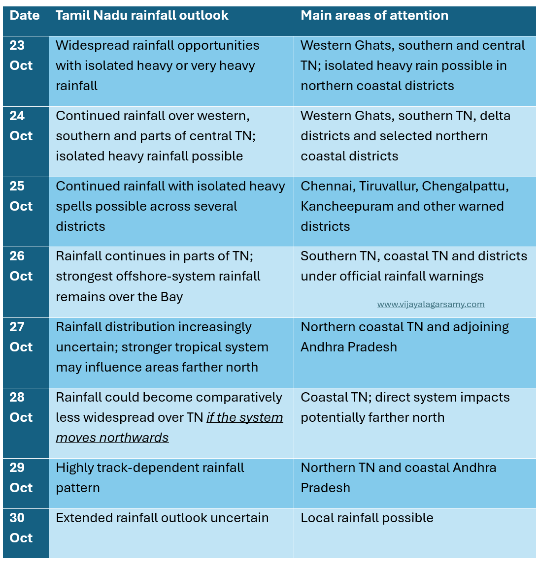
Date-Wise Rainfall Outlook for Tamil Nadu — 23 to 30 October 2026
The following table combines the latest available RMC Chennai rainfall guidance and my interpretation of the supplied ECMWF precipitation charts.
Chennai / NTN Region — District-Wise Rainfall Outlook
Date-Wise Outlook: 23–27 October
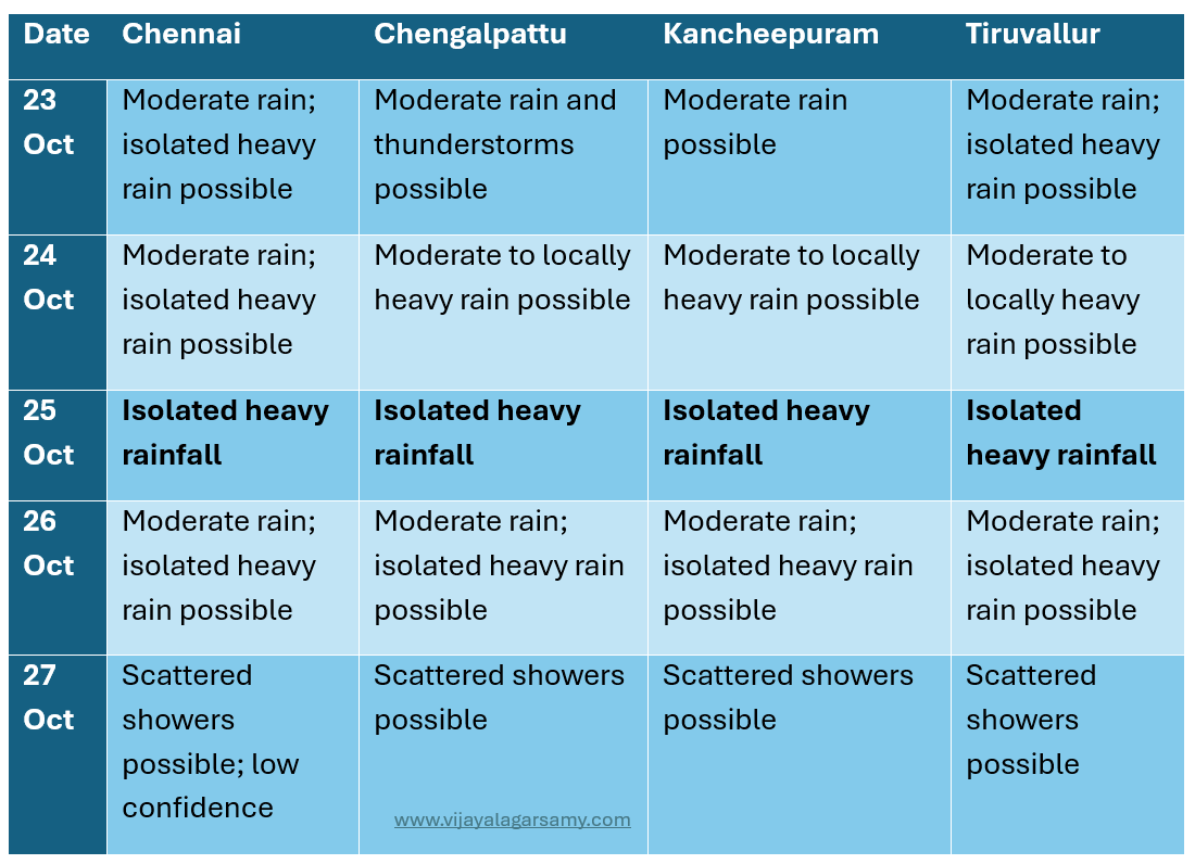
The 23–26 October risk descriptions incorporate reported RMC Chennai heavy-rainfall warnings. The 27 October forecast is a lower-confidence independent outlook.
Chennai
Chennai continues to have opportunities for moderate rainfall and thunderstorms during 23–26 October. The official forecast indicates isolated heavy-rainfall potential, particularly during the approaching weekend. However, the modelled tropical system intensifying over the Bay of Bengal is projected to remain farther offshore and subsequently move towards Andhra Pradesh.
Thus, Chennai's immediate rainfall risk is more closely associated with the existing regional circulation and associated rainbands than with a direct cyclone landfall. Short-duration intense rainfall remains possible even if the strongest offshore system does not approach Chennai.
Chengalpattu
Coastal Chengalpattu remains sensitive to incoming moisture-bearing winds and local coastal convergence. Areas around Mamallapuram, Kalpakkam and Tiruporur may experience different rainfall conditions from inland sections of the district.
The forecast indicates moderate rainfall opportunities with isolated heavy spells possible during 24–26 October.
Kancheepuram
Kancheepuram may receive rainfall associated with inland-moving convective clouds and organised rainbands from the Bay of Bengal. The possibility of isolated heavy rainfall exists during the warned period. However, the ECMWF rainfall maps do not establish a persistent, district-wide heavy-rainfall zone.
Tiruvallur
Tiruvallur, particularly its coastal sections around Pulicat and adjoining northern coastal areas, remains sensitive to atmospheric convergence and the movement of rainbands. The official forecast indicates isolated heavy-rainfall potential during 23–26 October. The district's eventual rainfall distribution will depend on how regional rain-bearing systems evolve.
Will the Intensifying Bay of Bengal System Bring Heavy Rain to Chennai?
This is one of the most important questions arising from the latest ECMWF forecast.
The model depicts a developing tropical disturbance that intensifies considerably during 25–27 October.
However, the increasingly organised system is also projected to move N or NW towards Andhra Pradesh.
The strongest modelled rainfall therefore becomes concentrated around the offshore circulation and its associated rainbands farther north.
As a result, the model does not indicate that the intensity of rainfall over Chennai must increase proportionately with the intensity of the tropical disturbance.
In fact, the geographical distribution of rainfall may change as the system moves away from the Tamil Nadu coastline.
However, this does not eliminate the possibility of isolated heavy rainfall over Chennai – this needs high monitoring related to the system’s track.
Final Inference
Northeast Monsoon 2026 is entering a period in which organised tropical activity over the Bay of Bengal may become increasingly significant. The latest forecasts indicate that the location of the rainbands is likely to be just as important as the strength of the developing circulation.
For Chennai, the potential for heavy rain from the existing regional circulation remains an immediate concern.
For the developing tropical disturbance, the modelled northward progression suggests that the stronger direct rainfall impacts may increasingly shift towards Andhra Pradesh.
The eventual outcome will depend on observations, continued system organisation and changes in the forecast track.
Model source: Model charts via Meteorologix
Official warning references: India Meteorological Department and Regional Meteorological Centre, Chennai.
Note: This is independent weather-model interpretation, not an official cyclone or district-level weather warning.
Updated: 23 October 2026 | 1030
NEM 2026 Update — 23 October: Invest 98B and a Strengthening Bay of Bengal Cyclonic Signal
Analysis updated: 23 October 2026
Data: ECMWF, GFS, JTWC, IMD-RMC
The Northeast Monsoon of 2026 continues to evolve, with a potentially significant tropical disturbance now being monitored over the Bay of Bengal.
In my previous updates, I discussed the differences between ECMWF, GFS and EC-AIFS model predictions regarding the possible development of organised tropical weather systems during the final week of October.
The Joint Typhoon Warning Center (JTWC) has designated the developing disturbance as Invest 98B.
Satellite imagery indicated a slowly consolidating low-level circulation (LLC) with persistent deep convection and developing, fragmented cloud bands. A broad cloud mass is visible around the developing disturbance, with areas of deeper convective activity. Cloud bands extend across parts of the central and southern Bay of Bengal. Additional convective cloud clusters are visible over the Arabian Sea and adjoining western peninsular region.
The estimated MSLP was approximately 1007 hPa, with maximum sustained surface winds of 5–10 knots in the supplied assessment.
Environmental Indicators (23/10/2026 | 08:30 am)
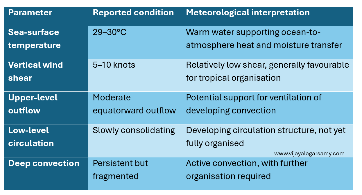
These conditions suggest that the environment has several characteristics favourable for tropical development.
Nevertheless, a tropical cyclone requires sustained organisation of the low-level circulation, convection and surrounding atmospheric flow. Invest 98B has favourable environmental ingredients for possible further development.
23–24 October: Developing Circulation
During the initial forecast period, ECMWF depicts a cyclonic circulation over the east-central Bay of Bengal. The circulation remains relatively broad, with lower-tropospheric winds curving around the developing centre. By 24 October, its likely that we can see a more clearly defined circulation.
25–26 October: Increasing Organisation
The forecast depicts an increasingly compact cyclonic circulation during 25–26 October. Wind speeds around the circulation increase, with a more clearly defined inner region. By 26 October, the system likely to have substantially more intense wind field than during the previous forecast period.
27–28 October: Strongest Modelled Intensification
The ECMWF forecast depicts a compact and intense cyclonic circulation over the west-central Bay of Bengal during 27–28 October. As per the model analysis, local 850 hPa wind speed of approximately 147 km/h within the modelled circulation is likely. This is a substantial wind speed at the lower-tropospheric pressure level.
However, 850 hPa wind speed must not be confused with sustained surface wind speed or surface gusts.
By 28 October, ECMWF depicts the circulation moving closer to the Andhra Pradesh coastal region.
29–30 October: Northward or Northwestward Progression
The subsequent forecast frames indicate a continued N or NW movement of the circulation, towards the Andhra Pradesh–Odisha sector and potentially farther inland, and then experience weakening or structural changes.
However, the projected track is subject to substantial uncertainty.
SST and Vertical Wind Shear
The reported sea-surface temperatures of 29–30°C and relatively low vertical wind shear of 5–10 knots are particularly relevant and are considered as highly favourable environmental conditions to the disturbance.
Warm ocean waters provide heat and moisture, while relatively low vertical wind shear can help a developing circulation maintain vertical organisation.
Moderate upper-level outflow may also contribute to the removal of air from the upper levels of organised convection.
Nevertheless, these conditions do not guarantee rapid intensification. The system must maintain persistent convective organisation, suitable moisture conditions and favourable atmospheric structure.
Two Weather Systems and Their Different Impacts on Tamil Nadu
It is important to distinguish Invest 98B from the earlier low-pressure system affecting the southwest Bay of Bengal and southern Tamil Nadu.
System A — Southwest Bay and Southern Peninsula
The existing low-pressure system over the southwest Bay of Bengal has been influencing rainfall across Tamil Nadu and adjoining areas.
By 22 October, its circulation was being reported around the Comorin region and adjoining southern Tamil Nadu and Kerala.
The RMC indicated that this system could continue to support rainfall and potentially influence northern Tamil Nadu as its circulation evolved. This system is particularly relevant to the immediate rainfall outlook over Chennai and neighbouring districts.
System B — Invest 98B
Invest 98B is the separate developing circulation farther east over the Bay of Bengal.
The forecast projects a more intense system during 26–28 October, followed by movement towards the Andhra Pradesh–Odisha region.
If this scenario materialises, the stronger direct impacts could occur along the Andhra Pradesh and Odisha coastal sectors rather than NTN or Chennai.
However, the eventual impact distribution will depend on the actual track and structure of the system.
Tamil Nadu's rainfall during the coming days should not be attributed entirely to Invest 98B.
Updated: 21 October 2026 | 1730
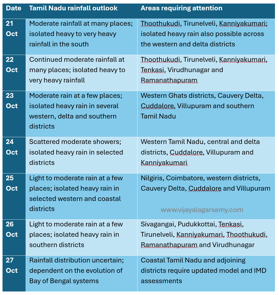
Date-Wise Rainfall Outlook for Tamil Nadu — 21 to 27 October 2026
The following outlook combines the RMC Chennai seven-day bulletin issued on 20 October with my interpretation of the ECMWF forecast charts initialised at 18 UTC on 20 October.
Rainfall warnings through 26 October are based on the official bulletin. The 27 October discussion is an extended outlook, not a verified district-level warning.
Interpretation of the Statewide Outlook
21–22 October
The heavier rainfall potential is concentrated over southern Tamil Nadu and selected western and delta districts. The existing SW Bay circulation and associated moisture transport are important contributors to this rainfall pattern.
23–24 October
As the second potential low-pressure system develops farther east over the Bay of Bengal, the geographical distribution of rainfall may change. However, the available official forecast continues to indicate isolated heavy rain over several western, central and delta districts.
25–26 October
The latest ECMWF forecast shows a more organised low-pressure system over the central-southern Bay of Bengal. But as of now the charts show heavy rains remains largely offshore.
27 October
The eventual rainfall impact remains uncertain because it depends on the subsequent track, intensity and position of the developing Bay of Bengal system.
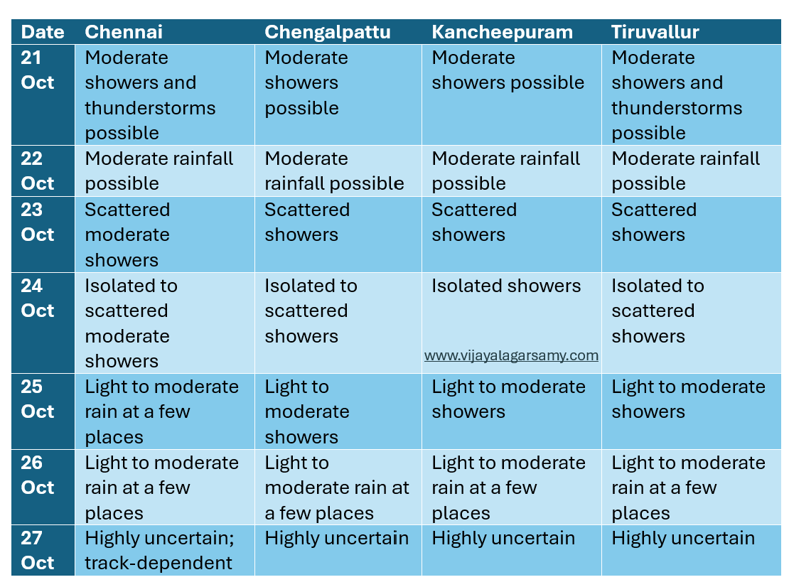
Chennai, Chengalpattu, Kancheepuram and Tiruvallur — District-Wise Rainfall Outlook
The four districts surrounding the Chennai metropolitan region are geographically close, but their rainfall distribution can vary significantly.
Coastal exposure, local atmospheric instability, movement of rainbands and the direction of moisture transport can produce different rainfall totals within relatively short distances.
The current RMC Chennai forecast does not individually list these four districts under its heavy-rainfall warnings for 21–26 October.
However, light-to-moderate rainfall and thunderstorms remain possible, and locally intense convective rainfall cannot be ruled out.
Date-Wise Outlook
District-Specific Interpretation
Chennai
For Chennai, the immediate outlook indicates continued opportunities for moderate rainfall and thunderstorms during 21–23 October.
Rainfall is expected to be intermittent rather than necessarily continuous throughout the day.
From 24–26 October, rainfall may become more scattered, depending on the movement of the existing circulation and the development of the second system.
The latest ECMWF precipitation forecast does not depict the strongest rainbands directly over Chennai during 25–26 October.
Nevertheless, short-duration intense thunderstorms remain possible even without a direct cyclone influence.
Chengalpattu
Consequently, rainfall distribution may vary between its coastal belt and interior regions. Intermittent moderate rainfall is possible during 21–23 October, with more scattered rainfall thereafter.
Areas around Mamallapuram, Kalpakkam, Tiruporur and adjoining coastal locations may respond more directly to moisture-bearing winds from the Bay of Bengal.
Meanwhile, inland areas may depend more on the development and movement of local convective clouds.
Kancheepuram
Rainfall will be particularly sensitive to the inland movement of rainbands and the development of convective activity. If rainfall remains concentrated offshore, Kancheepuram may experience comparatively fewer showers.
However, an inland-moving trough or convective rainband could produce significant local rainfall. Moderate showers are possible during the immediate period, followed by scattered light-to-moderate rainfall opportunities during 23–26 October. The available forecasts do not establish a district-wide heavy-rainfall event.
Tiruvallur
The coastal belt around Pulicat and Ennore's northern surroundings may respond differently from interior areas such as Tiruttani or western Tiruvallur.
The arrival of organised rainbands from the Bay of Bengal could increase rainfall over the district. Moderate rainfall and thunderstorms remain possible during 21–22 October, with more scattered rainfall during 23–26 October.
Why Can Chennai Experience Heavy Rain Without a Cyclone?
An important consideration during Northeast Monsoon forecasting is that significant rainfall does not always require a depression or cyclonic storm.
Chennai can receive intense rainfall from easterly waves, low-level convergence, upper-air circulations and local convective systems.
When moisture-bearing easterly winds approach the coast, favourable convergence and atmospheric instability may produce organised cloud clusters.
If these cloud systems move slowly or repeatedly pass over the same area, rainfall accumulation can increase significantly.
This is sometimes described as repeated rainband activity or training convection.
Therefore, even if the stronger Bay of Bengal system remains offshore, the Chennai region may still experience localised thunderstorms.
However, determining the timing and location of such events requires shorter-range forecasts, radar observations and real-time satellite imagery.
What Could Increase the Rainfall Potential Across the Four Districts?
The rainfall outlook for Chennai, Chengalpattu, Kancheepuram and Tiruvallur would become more significant if subsequent observations and model forecasts indicate:
Persistent easterly or northeasterly moisture transport towards the north Tamil Nadu coast.
Development of a trough or cyclonic circulation over the southwest Bay close to Chennai.
Westward movement of organised rainbands towards the coast.
Increased low-level moisture convergence.
A slow-moving rainfall system capable of producing prolonged precipitation.
Conversely, rainfall potential could decrease if the stronger low-pressure circulation remains offshore, moves northwards or concentrates atmospheric convergence away from Tamil Nadu.
Updated: 21 October 2026 | 1000
System 1 — Southwest Bay of Bengal and Tamil Nadu Coast
An upper-air cyclonic circulation (UAC) extending up to ~5.8 km above MSL persists over the SW Bay of Bengal and adjoining Tamil Nadu coast. Under its influence, a low-pressure area (LPA) is likely to develop over the region within the following 12 hours. This system is particularly relevant to the immediate rainfall pattern over Tamil Nadu.
System 2 — Southeast and East-Central Bay of Bengal
Another UAC over the Gulf of Thailand and adjoining Thailand–Myanmar region is likely to emerge into the north Andaman Sea. Under its influence, a separate LPA is expected to develop over the SE and adjoining east-central Bay of Bengal around 23 October.
IMD indicated that the system could move NW and intensify further during the subsequent three days. Interestingly, the latest ECMWF deterministic forecast also depicts increasing cyclonic vorticity, a developing closed surface-pressure circulation and organised precipitation bands over the central-southern Bay of Bengal by 25–26 October. The model forecasts a central pressure of approximately 999 hPa by 18 UTC on 26 October.
My combined-effects inference: There is currently no sufficient evidence to conclude that the two potential low-pressure systems will merge or jointly produce a major rainfall event over Chennai. The broader tropical atmosphere appears supportive of continued weather activity over the Bay of Bengal during late October. However, the actual rainfall over Tamil Nadu, particularly the northern coastal districts, will be governed primarily by the position and movement of the weather systems, low-level moisture convergence and the organisation of rainbands.
Analysis date: 17 October 2026
NEM 2026 — Key Developments at a Glance
The Northeast Monsoon of 2026 has officially commenced over southern India, with several atmospheric and oceanic indicators presenting an interesting background for the coming months.
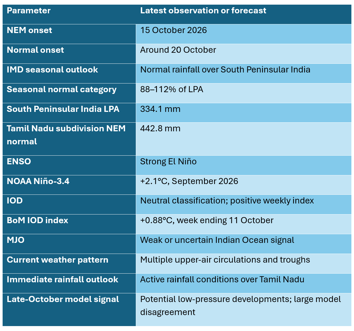
These indicators provide the background for analysing how Northeast Monsoon 2026 might evolve.
However, the seasonal outlook and short-range weather forecasts describe different aspects of the atmosphere and should not be interpreted as interchangeable predictions.
SWM Withdrawal and NEM Onset
On 15 October 2026, the India Meteorological Department officially announced that the Southwest Monsoon had withdrawn from the entire country.
Simultaneously, Northeast Monsoon rainfall activity commenced over Tamil Nadu, Puducherry and Karaikal, Coastal Andhra Pradesh, Rayalaseema, South Interior Karnataka, and Kerala and Mahe.
The official onset occurred approximately five days earlier than the climatological onset date of 20 October.
According to IMD, the onset was associated with several meteorological developments.
An upper-air cyclonic circulation was present over southern coastal Tamil Nadu and adjoining areas.
Easterly and northeasterly winds had become established over southern peninsular India and adjoining parts of the Bay of Bengal.
Additionally, fairly widespread rainfall occurred over Tamil Nadu, Puducherry, Karaikal and adjoining areas during the preceding 24 hours, with heavy rainfall recorded at a few locations.
Together, these observations confirmed the beginning of the Northeast Monsoon rainfall season.
Is an early onset an indication of a wetter season?
Not necessarily.
An early onset indicates that the atmospheric circulation has transitioned into the Northeast Monsoon regime ahead of the normal date.
It does not establish the eventual cumulative seasonal rainfall.
For a good monsoon season, the persistence of favourable circulation, frequency of rainfall-producing systems, moisture availability and distribution of rainfall across October, November and December are important.
An early onset followed by prolonged dry spells may still result in below-normal rainfall.
Conversely, a comparatively late onset followed by multiple active rainfall spells may result in normal or above-normal seasonal rainfall.
My observation: The early onset of NEM 2026 is meteorologically significant, but it is too early to infer the eventual performance of the season based on onset timing alone.
Figure 1: Withdrawal of Southwest Monsoon 2026 — IMD chart.
Source: IMD, 15 October 2026.
IMD Seasonal Outlook — October to December 2026
The IMD released its seasonal forecast for the post-monsoon period on 30 September 2026.
According to this forecast, rainfall during October–December over South Peninsular India is most likely to be normal, corresponding to 88–112% of the Long Period Average.
The LPA for this wider region is approximately 334.1 mm, based on rainfall observations from 1971–2020.
This region includes Tamil Nadu, Puducherry and Karaikal; Coastal Andhra Pradesh and Yanam; Rayalaseema; Kerala and Mahe; and South Interior Karnataka.
It is important not to confuse this regional average with the climatological rainfall normal for Tamil Nadu or Chennai.
The Tamil Nadu–Puducherry–Karaikal subdivision receives approximately 442.8 mm of normal rainfall during October–December, while the Chennai Nungambakkam station has an October–December normal of approximately 856.3 mm under its 1991–2020 climatology.
These figures represent different geographical areas and climatological reference periods.
What does a normal seasonal forecast indicate?
The IMD's 88–112% range identifies the normal seasonal rainfall category, not a prediction that every location will receive the same percentage of its normal rainfall.
The forecast suggests that the combined seasonal rainfall across the five South Peninsular meteorological subdivisions is most likely to fall within that normal category.
However, the spatial distribution may vary considerably.
Some districts may receive excess rainfall while others experience rainfall deficits.
The number of rainy days and the occurrence of intense rainfall episodes may also differ from the long-term average.
Rainfall outlook for October 2026
For India as a whole, IMD expects below-normal rainfall during October 2026, at less than 85% of the national LPA.
However, southern portions of peninsular India are among the regions where normal to above-normal rainfall is possible.
This distinction is important.
A forecast of below-normal rainfall for India as a whole does not necessarily indicate below-normal rainfall for Tamil Nadu.
Similarly, normal seasonal rainfall over South Peninsular India does not guarantee normal rainfall for Chennai.
My inference: The regional seasonal outlook is broadly supportive of a normal Northeast Monsoon, but the eventual rainfall distribution over Tamil Nadu will depend on active weather systems during October–December.
ENSO Status — A Strong El Niño Is Developing
One of the most significant global climate conditions associated with NEM 2026 is the strengthening El Niño over the equatorial Pacific.
According to NOAA's ENSO Diagnostic Discussion issued on 8 October 2026, El Niño conditions have continued to strengthen, with significant warming across the central and eastern equatorial Pacific Ocean.
The September Niño-region sea-surface temperature anomalies were:
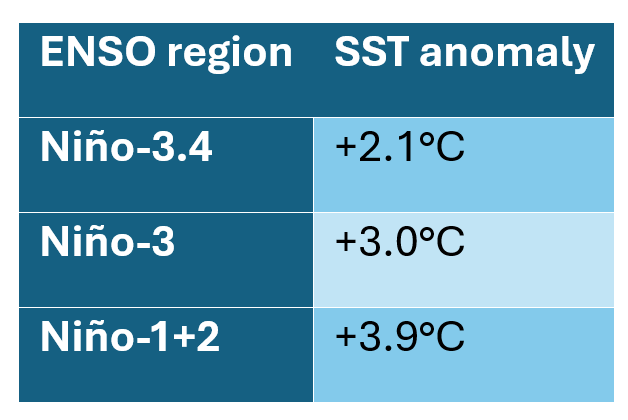
NOAA also reported subsurface warm anomalies, altered equatorial wind circulation, enhanced convection over parts of the central and eastern Pacific, and suppressed convection around Indonesia.
These conditions indicate that the oceanic warming is accompanied by a corresponding atmospheric response.
This ocean-atmosphere coupling is an important characteristic of an established El Niño event.
NOAA's October outlook estimated an 83% probability of the October–December three-month relative oceanic Niño index reaching or exceeding +2.5°C — an exceptionally high threshold relative to its historical record.
However, this is a probability forecast for an ENSO intensity threshold, not an 83% probability of excess rainfall or flooding in Tamil Nadu.
Additional observations from the Australian Bureau of Meteorology
The Bureau of Meteorology's update dated 13 October 2026 reported a weekly relative Niño-3.4 index of +2.81°C for the week ending 11 October.
The 30-day Southern Oscillation Index was −20.2, consistent with strong El Niño atmospheric conditions.
The Bureau also indicated that El Niño could strengthen further towards November or December.
The NOAA monthly Niño-3.4 anomaly and the Bureau's weekly relative Niño-3.4 index have different definitions and reference frameworks and should not be directly compared as if they represented identical measurements.
What could this mean for NEM 2026?
Historically, El Niño conditions have frequently been associated with enhanced Northeast Monsoon rainfall over southern peninsular India.
This differs from the often negative relationship between El Niño and the Indian Southwest Monsoon.
Possible mechanisms include changes in the Walker Circulation, regional tropical convection, easterly wind anomalies and moisture convergence over parts of the Indian Ocean.
However, these teleconnections are not uniform across every event.
Strong El Niño conditions may alter the background probability of seasonal rainfall, but the actual outcome depends on the combined influence of Indian Ocean conditions and regional weather systems.
My inference: The strong El Niño of 2026 is an important climate signal to monitor throughout the NEM season.
It provides a historical basis for considering the possibility of enhanced seasonal rainfall, but it is not sufficient to predict above-normal rainfall for Chennai or Tamil Nadu independently of other factors.
For detailed ENSO observations and analysis, refer to:
Indian Ocean Dipole — Positive Values, but an Uncertain Event
The Indian Ocean Dipole is another important parameter that deserves attention during NEM 2026.
The IMD's seasonal outlook issued on 30 September indicated neutral IOD conditions, with its model guidance suggesting that neutral conditions were most likely to continue through the Northeast Monsoon season.
However, observations from the Australian Bureau of Meteorology reveal a developing positive IOD index signal.
According to its 13 October update, the IOD index reached +0.88°C for the week ending 11 October.
This was the fifth consecutive week during which the index remained above the commonly used positive-IOD threshold of +0.4°C.
Nevertheless, the Bureau continued to classify the IOD as neutral because the criteria for declaring an established positive event had not yet been fulfilled.
Its forecasts suggested that a positive IOD might develop, although uncertainty remained regarding its intensity and duration.
Why is this important?
The IOD can influence the distribution of tropical convection and atmospheric moisture across the Indian Ocean.
Its effect on Northeast Monsoon rainfall is not independent of ENSO and other regional circulation systems.
The interaction between the strengthening Pacific El Niño and evolving Indian Ocean temperature gradients could influence rainfall patterns across southern India.
However, the direction and magnitude of the response cannot be determined from the IOD index alone.
My inference: While ENSO currently provides a clearer large-scale climate signal, the positive weekly IOD index values are worth monitoring.
A sustained positive IOD event, if established, could alter the regional atmospheric background during NEM 2026.
Further observations are needed before drawing conclusions regarding its influence on Tamil Nadu rainfall.
Madden–Julian Oscillation — Will It Support an Active Rainfall Phase?
The Madden–Julian Oscillation is important for understanding subseasonal rainfall variability and tropical atmospheric activity.
For NEM 2026, the evolution of the MJO could influence the timing of active and relatively suppressed rainfall periods over the Indian Ocean region.
According to the ASEAN Specialised Meteorological Centre's subseasonal outlook issued on 7 October 2026, the MJO signal remained uncertain.
Some model guidance indicated possible emergence of MJO activity over the Indian Ocean, particularly phases 2 and 3, during 12–18 October.
Other models suggested that significant MJO activity might not develop during the same period.
Thus, there was no clear multi-model agreement on a sustained active MJO signal.
Why do the MJO phases matter?
The passage of an enhanced convective MJO phase through the Indian Ocean can support greater tropical cloudiness and rainfall under favourable conditions.
However, the impact depends on the strength and organisation of the MJO, as well as interaction with the background atmospheric circulation.
An MJO signal in phases 2–4 with sufficient amplitude may provide a supportive environment for Northeast Monsoon rainfall, but does not guarantee the formation of a low-pressure area or cyclone.
My inference: The MJO is an important indicator to track during the coming weeks, especially if enhanced convective activity becomes established over the Indian Ocean.
At present, the available forecast information does not justify attributing Tamil Nadu's ongoing rainfall to a confirmed strong MJO event.
Sea-Surface Temperature and the Bay of Bengal
Sea-surface temperature is another important parameter influencing tropical convection and the development of low-pressure systems.
Warm ocean waters provide heat and moisture to the lower atmosphere.
However, the resulting weather depends on the interaction of oceanic conditions with atmospheric instability, wind shear and circulation.
For Tamil Nadu, particular attention should be given to the southwest and west-central Bay of Bengal because of their proximity to the state's eastern coastline.
During active Northeast Monsoon conditions, persistent easterly or northeasterly moisture transport across these waters can support organised rainfall.
What do the current charts indicate?
The ECMWF, EC-AIFS and GFS charts examined in this analysis primarily display wind speed at 850 hPa, geopotential height and mean sea-level pressure centres.
They do not directly display sea-surface temperature or ocean heat content.
Consequently, no specific Bay of Bengal SST anomaly can be established from these maps.
To assess whether the Bay of Bengal is unusually warm during October 2026, separate observed SST anomaly products from reliable agencies are necessary.
My inference: Sea-surface temperature and ocean heat availability will remain important supporting parameters for tropical disturbances during NEM 2026.
However, any suggestion of unusually favourable conditions for tropical cyclone development must be supported by observed ocean temperature data together with atmospheric analyses.
IMD Synoptic Analysis — Multiple Circulation Systems Over Southern India
The IMD meteorological analysis issued on 16 October 2026 identified several important atmospheric features over southern peninsular India.
An upper-air cyclonic circulation was present over Tamil Nadu between approximately 3.1 km and 4.5 km above mean sea level.
Another cyclonic circulation persisted over southern coastal Andhra Pradesh and its neighbourhood, extending up to approximately 1.5 km above mean sea level.
A trough extended from the southern coastal Andhra Pradesh circulation towards the northwest Bay of Bengal.
Additionally, a cyclonic circulation was present over northern Lakshadweep and its neighbourhood, extending up to approximately 5.8 km above mean sea level.
Why are these systems significant?
Cyclonic circulations and troughs can influence rainfall through changes in atmospheric convergence and vertical motion.
They may help transport or concentrate moisture and support the development of convective clouds.
The interaction between these circulation features and the evolving Northeast Monsoon winds can influence rainfall distribution over Tamil Nadu and adjoining regions.
However, these systems exist at different atmospheric levels and do not necessarily form a single continuous circulation.
It is also important to distinguish between an upper-air cyclonic circulation and a surface low-pressure system.
The presence of an upper-air circulation does not automatically imply the development of a depression or cyclone.
My observation: The onset phase of NEM 2026 has been accompanied by several circulation features across southern India and surrounding waters, supporting an unsettled regional weather pattern.
IMD Rainfall Forecast — 16 to 23 October 2026
The IMD's all-India weather bulletin issued on 16 October forecast fairly widespread to widespread rainfall over Tamil Nadu, Puducherry and Karaikal during 16–22 October.
The bulletin also indicated isolated very heavy rainfall during 16–20 October and isolated heavy rainfall during 21–22 October.
Thunderstorms, lightning and gusty winds reaching 40–50 km/h, with gusts up to 60 km/h, were forecast at isolated locations during the period.
The Regional Meteorological Centre Chennai's subdivision warning issued on 17 October continued to indicate very heavy rainfall potential during 17–20 October and heavy rainfall potential during 21–23 October.
These are forecasts for the wider meteorological subdivision, not assurances that every district will receive these rainfall amounts.
Understanding IMD rainfall classifications
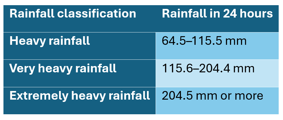
The distinction is important when interpreting weather bulletins.
An isolated very heavy rainfall warning means that such rainfall is possible at one or more locations within the relevant forecast area.
It does not mean that the entire subdivision will receive very heavy rainfall.
Rainfall already recorded during the onset phase
IMD reported 18 cm of rainfall at Adayamadai in Kanyakumari district during the 24-hour period ending at 8:30 AM IST on 16 October.
This illustrates that substantial rainfall had already occurred at some locations during the early phase of the Northeast Monsoon.
However, one significant rainfall observation cannot establish whether the entire season will be wetter than normal.
The cumulative rainfall over subsequent weeks and months will provide a more meaningful assessment.
ECMWF Model Analysis — 17 to 22 October
To examine the likely evolution of atmospheric circulation around the Indian subcontinent, I considered the ECMWF Integrated Forecasting System (IFS) charts initialised at 18 UTC on 16 October 2026.
The charts display wind speed at 850 hPa, geopotential height and mean sea-level pressure centres.
The supplied forecast sequence covers 17–22 October.
17–18 October
The initial forecast frames indicate weak low-pressure features over parts of peninsular India and adjoining waters.
The modelled pattern is broadly consistent with an unsettled onset phase, although the charts alone cannot establish where the strongest rainfall will occur.
19–20 October
The model continues to depict comparatively weak low-pressure centres and lower-tropospheric circulation features across parts of India and the adjoining seas.
These circulation patterns could influence regional rainfall, depending on moisture availability and atmospheric instability.
21–22 October
The later frames continue to show low-pressure activity across the broader region, but do not depict a clearly organised tropical cyclone approaching the Tamil Nadu coast.
Interpretation
The conventional ECMWF charts indicate continued atmospheric variability during the onset period.
My inference: The ECMWF sequence supports monitoring the development of circulation features around southern India, but does not provide sufficient evidence to predict a major cyclone or quantify rainfall over Chennai.
Importantly, the ECMWF sequence supplied here ends on 22 October, so it cannot be used to confirm or reject the longer-range projections made by EC-AIFS and GFS for the final week of October.
ECMWF 850 hPa wind and MSLP charts, 17–22 October 2026.
Source: Tropical Tidbits.
EC-AIFS Analysis — Possible Low-Pressure Development Near Tamil Nadu
The ECMWF Artificial Intelligence Forecasting System (EC-AIFS) provides an additional perspective on how the atmospheric circulation might evolve during the second half of October.
The EC-AIFS run initialised at 18 UTC on 16 October extends through 31 October 2026.
Unlike the conventional ECMWF sequence provided, this longer forecast shows recurring low-pressure signals around southern India during the final week of October.
17–23 October
During the early forecast period, EC-AIFS depicts relatively weak low-pressure features across parts of southern India and the surrounding seas.
The model does not show a clearly established intense cyclonic storm close to Tamil Nadu during these early frames.
24–26 October
The forecast suggests continued reorganisation of low-pressure features across the southern peninsula and adjoining southwest Bay of Bengal.
By 26 October, the model depicts a low-pressure centre of approximately 1007 hPa in the region.
27–29 October
The model shows a potentially more organised circulation developing near the Tamil Nadu–Sri Lanka region.
The labelled central pressure values in this deterministic run evolve approximately as follows:
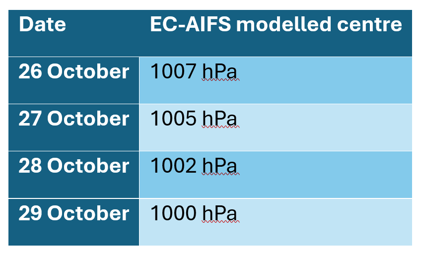
This progression suggests modelled strengthening of a low-pressure system.
However, these figures are individual forecast outputs and must not be considered observed atmospheric pressure or a confirmed future cyclone.
30–31 October
Subsequent frames indicate changes in the position and structure of the circulation, together with a weakening or reorganisation of the modelled low.
What could this mean for Tamil Nadu?
A low-pressure system developing near the southwest Bay of Bengal or Tamil Nadu coast could potentially support enhanced rainfall if it draws sustained moisture towards the coastline.
The resulting rainfall distribution would depend on the location of the circulation, its movement and the configuration of associated rainbands.
A circulation situated farther inland or over the Arabian Sea may produce a very different rainfall pattern.
My inference: EC-AIFS provides an early signal of possible organised low-pressure activity near southern India during approximately 26–30 October.
This is a development worth monitoring, especially for coastal Tamil Nadu.
However, because the forecast extends approximately 10–14 days ahead, uncertainty in the system's timing, intensity and position remains high.
The model projection should not be treated as confirmation of cyclone formation or significant rainfall over Chennai.
EC-AIFS 850 hPa circulation charts, valid 26–29 October 2026.
Source: Tropical Tidbits.
GFS Model Analysis — Stronger Tropical Systems, but Different Locations
The Global Forecast System (GFS), operated by NOAA's National Centers for Environmental Prediction, offers another perspective on possible tropical developments.
The GFS run initialised at 18 UTC on 16 October 2026 displays a substantially different evolution compared with EC-AIFS during late October.
This difference is particularly important when evaluating the potential weather impacts over Tamil Nadu.
17–23 October
During the first several days, GFS depicts weak low-pressure circulations around parts of peninsular India and adjoining seas.
Meanwhile, a separate system develops over the wider Indian Ocean region.
These early frames suggest an unsettled circulation pattern but do not establish a major cyclone approaching Tamil Nadu.
24–26 October — Intensification Over the Arabian Sea
Around 24–26 October, the model indicates a more organised low-pressure circulation over the eastern Arabian Sea.
By 26 October, GFS depicts a central mean sea-level pressure of approximately 994 hPa.
This is significantly lower than the corresponding low-pressure centre depicted near southern India by EC-AIFS.
27–29 October — Strong Arabian Sea Signal
The GFS forecast intensifies the Arabian Sea system considerably.
The model depicts a central pressure of approximately:
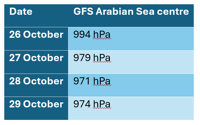
These low pressure values, together with the compact circulation shown in the wind fields, represent an intense tropical-system scenario within this particular deterministic forecast run.
However, this is not an official cyclone prediction.
At such long forecast lead times, tropical cyclone intensity and track projections can change substantially between successive model runs.
28–30 October — Another System Over the Northern Bay of Bengal
Interestingly, GFS also depicts a separate potentially intense low-pressure system developing over the northern Bay of Bengal region.
The model suggests strengthening around 28–30 October, with a labelled minimum central pressure approaching approximately 970 hPa by 30 October.
The projected position is considerably farther north than the Tamil Nadu coast.
If a northern Bay system were to develop along this general scenario, its primary rainfall and wind impacts could occur farther north, depending on its eventual movement.
What does GFS indicate for Chennai?
Although the model depicts intense tropical systems during the final week of October, neither of its strongest late-period systems is clearly projected to approach Chennai directly in this run.
Therefore, the appearance of very low central pressures over the Arabian Sea or northern Bay of Bengal cannot be interpreted as a direct prediction of extreme rainfall in Chennai.
My inference: The GFS forecast suggests the possibility of significant tropical weather activity over the North Indian Ocean during late October.
However, its stronger projected systems are situated away from Tamil Nadu.
The forecast differs substantially from EC-AIFS in the location and intensity of low-pressure development.
This reduces confidence in any specific long-range prediction for Tamil Nadu based solely on these charts.
GFS Arabian Sea system, valid 26–29 October 2026.
GFS northern Bay of Bengal system, valid 28–30 October 2026.
Source: Tropical Tidbits.
ECMWF vs EC-AIFS vs GFS — What Do the Models Agree On?
Comparing multiple numerical weather prediction models is useful because each model represents atmospheric processes differently.
However, models should not be expected to provide identical predictions, especially beyond seven days.
For NEM 2026, the three supplied model sequences reveal both similarities and important differences.
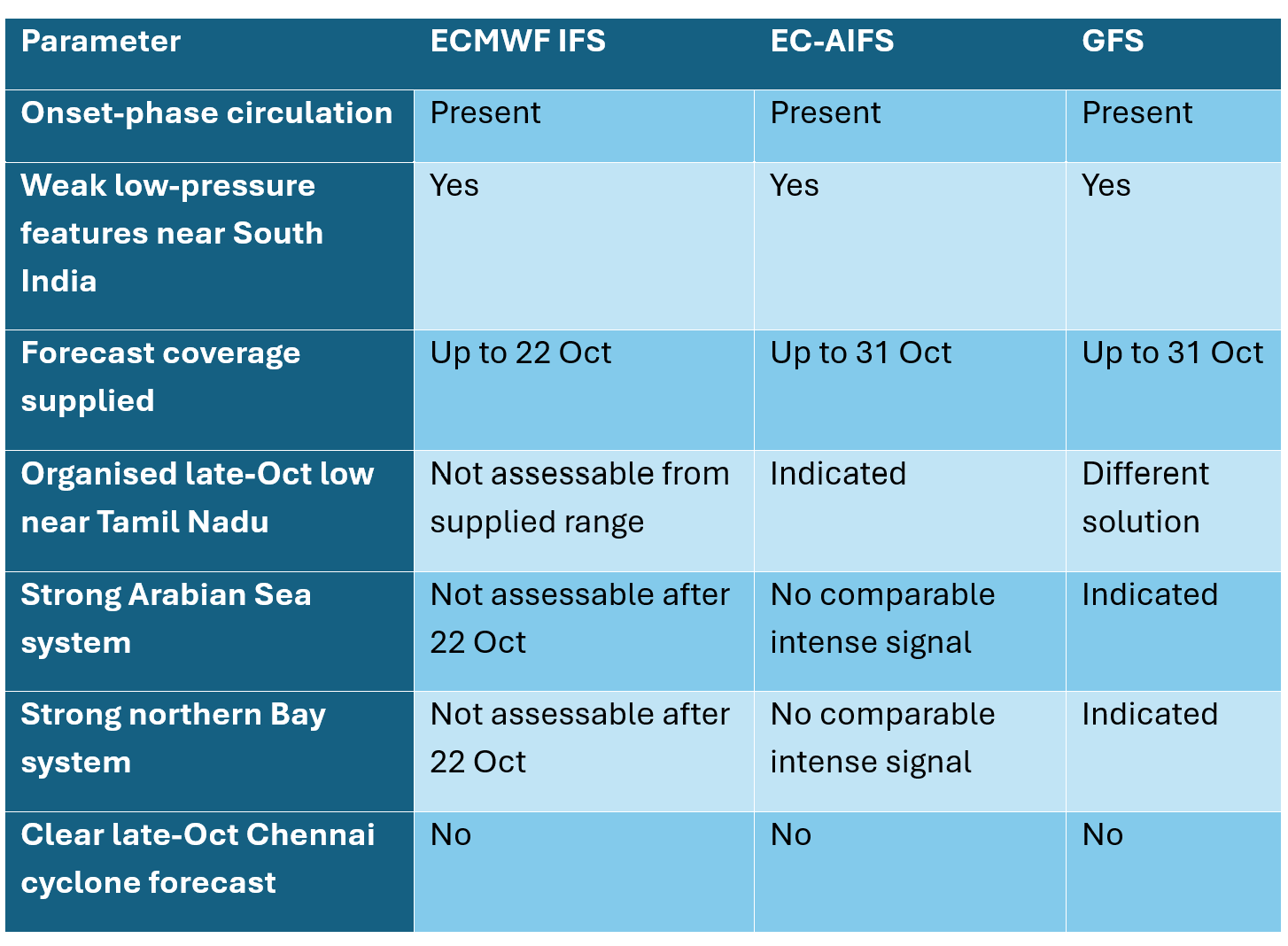
What can be inferred from this comparison?
First, all three model sequences depict atmospheric circulation activity around India and the neighbouring seas during the early Northeast Monsoon period.
Second, EC-AIFS and GFS indicate the possibility of more organised tropical systems during the final week of October, but differ significantly in their locations and projected strengths.
Third, the conventional ECMWF sequence currently available in this analysis ends on 22 October and therefore does not provide a direct comparison for the late-October systems.
Fourth, no convincing agreement exists in the supplied deterministic charts regarding an intense cyclonic storm approaching Chennai.
Why is model disagreement important?
When multiple forecasting systems consistently identify a similar atmospheric development, confidence in the broader signal can increase.
However, agreement between models is not a guarantee of accuracy.
Similarly, disagreement does not necessarily mean that no system will develop.
It means there is uncertainty concerning the eventual evolution.
For tropical weather systems, changes in initial atmospheric conditions, model resolution and treatment of convection can produce substantial differences in predicted tracks and intensities.
EC-AIFS also has recognised limitations in representing the intensity of certain tropical cyclones.
Consequently, it would be inappropriate to favour a model merely because it predicts the strongest or weakest system.
My assessment: The present multi-model comparison suggests a possibility of increased tropical weather activity during late October, but confidence remains low regarding the location, intensity and rainfall impact of individual projected systems.
Further observations and successive model runs will be essential.
Rainfall Outlook for Tamil Nadu — October 2026
Based on the IMD forecasts and the available numerical model charts, the early phase of Northeast Monsoon 2026 is expected to remain active across Tamil Nadu.
However, the likely distribution and intensity of rainfall vary across geographical regions.
Northern Coastal Tamil Nadu
Districts such as Chennai, Tiruvallur, Chengalpattu, Kancheepuram and adjoining coastal areas are sensitive to moisture transport from the Bay of Bengal.
Rainfall can increase when favourable easterly winds, troughs or low-pressure systems support moisture convergence over the coast.
The positioning of weather systems relative to the coastline will be particularly important.
Central and Delta Coastal Districts
Areas around Cuddalore, Mayiladuthurai, Nagapattinam, Tiruvarur and the wider Cauvery Delta can receive substantial rainfall from easterly waves and Bay of Bengal disturbances.
The movement of low-pressure systems towards the central Tamil Nadu coast can influence rainfall concentration across these areas.
Southern Tamil Nadu
The ongoing circulation pattern and regional atmospheric instability may support significant rainfall across parts of southern Tamil Nadu.
The 18 cm rainfall observation at Adayamadai in Kanyakumari district during the onset phase indicates that substantial local rainfall is already possible.
However, such observations do not establish a uniform rainfall trend across southern districts.
Western and Interior Tamil Nadu
Rainfall across western and interior districts depends on regional circulation, atmospheric instability, moisture transport and local topography.
During the onset period, the interaction between circulation systems and the Western Ghats may favour heavy rainfall at selected locations.
Statewide Assessment
The immediate IMD forecast supports widespread rainfall opportunities during the onset period, with isolated heavy to very heavy rainfall possible.
Beyond the short-range forecast, the rainfall pattern will depend on how easterly waves, troughs and low-pressure systems evolve.
The strong El Niño background provides an important seasonal climate signal, but does not establish how rainfall will be distributed across Tamil Nadu.
Chennai Rainfall Outlook — Immediate and Extended Period
Chennai deserves particular attention because of its position along the western Bay of Bengal and its dependence on October–December rainfall.
Based on the climatological records, November is normally the wettest month at the Nungambakkam observatory, followed by October and December.
However, actual seasonal rainfall can be concentrated within a relatively small number of significant events.
17–20 October: Active Regional Rainfall Conditions
The IMD regional forecast indicates continued rainfall and thunderstorm potential across Tamil Nadu, with very heavy rainfall possible at isolated locations within the subdivision.
For Chennai, intermittent rainfall and thunderstorms are possible during this period.
However, the severity of rainfall must be assessed from Chennai-specific and district-level forecasts rather than subdivision-wide warnings alone.
21–23 October: Continued Rainfall Opportunities
IMD guidance continues to indicate heavy rainfall potential at isolated locations across the Tamil Nadu meteorological subdivision.
The precise timing, duration and intensity of rainfall over Chennai remain dependent on the movement of regional rain-bearing systems.
24–26 October: Monitoring the Circulation Pattern
The EC-AIFS and GFS model sequences show evolving low-pressure features in and around the broader southern Indian region.
However, the forecast lead time is increasing, and confidence in specific rainfall outcomes begins to decrease.
At present, it is more appropriate to monitor the persistence of the circulation signal than to predict a rainfall amount for Chennai.
27–31 October: Potentially Important, but Highly Uncertain
EC-AIFS indicates the possibility of a low-pressure system closer to Tamil Nadu during this period.
GFS, meanwhile, depicts stronger systems over the Arabian Sea and northern Bay of Bengal.
These are significantly different atmospheric scenarios.
A developing system close to the southwest Bay of Bengal could potentially enhance rainfall along the Tamil Nadu coast if favourable easterly moisture transport becomes established.
However, the currently available model sequences do not justify predicting a major Chennai rainfall event during this period.
Chennai — My Interpretation
The Northeast Monsoon has begun with active regional rainfall conditions.
The immediate forecast supports continued rainfall opportunities, including the possibility of locally intense thunderstorms.
The final week of October deserves attention because of the low-pressure signals appearing in extended numerical forecasts.
However, there is currently insufficient agreement between the supplied models to forecast a specific major cyclone or extreme rainfall event affecting Chennai during 27–31 October.
The most useful indicators to monitor will be the direction and persistence of lower-tropospheric winds, development of low-pressure systems over the southwest Bay, moisture convergence near the coast, and consistency across successive model runs.
Could NEM 2026 Resemble 2015 or 2023?
Comparing Northeast Monsoon 2026 with previous seasons is interesting because some of the same large-scale climate indicators are present.
The 2015 season was associated with a very strong El Niño and produced exceptionally heavy rainfall and devastating flooding over Chennai.
The December 2023 rainfall events associated with Cyclone Michaung also demonstrated how significant coastal weather systems can produce widespread urban flooding.
However, the meteorological mechanisms and rainfall distributions were not identical.
Scientific studies examining the 2015 Chennai floods have identified several interacting factors, including tropical atmospheric variability, strong moisture transport, regional ocean temperature conditions, easterly waves, organised weather systems and local hydrological conditions.
A warmer Bay of Bengal and favourable atmospheric circulation can contribute to heavy rainfall potential, but ENSO alone cannot determine the occurrence of catastrophic flooding.
Urban factors such as land-use changes, impervious surfaces, drainage efficiency and floodplain development can also strongly influence the severity of inundation.
Can 2015 repeat in 2026?
From the available evidence, such a prediction would be premature.
Although NEM 2026 is occurring under strong El Niño conditions, individual extreme rainfall events depend on the formation, movement and interaction of regional weather systems.
The important lesson from previous seasons is not that similar events must recur.
Rather, it is that several atmospheric and oceanic parameters must align to produce prolonged and intense rainfall, while local drainage and catchment conditions determine how rainfall translates into flooding.
Thus, historical comparisons are valuable for understanding possible mechanisms and improving preparedness, but they should not be treated as direct rainfall forecasts for 2026.
What Could Make NEM 2026 Wetter or Drier Than Expected?
Although the official seasonal forecast indicates normal rainfall over South Peninsular India, actual rainfall performance will depend on how atmospheric conditions evolve through the season.
Conditions That Could Support Enhanced Rainfall
Persistent easterly and northeasterly moisture transport, repeated easterly waves, favourable moisture convergence, organised Bay of Bengal low-pressure systems and active tropical convection could increase rainfall opportunities over Tamil Nadu.
An active MJO over the Indian Ocean, if established, could also support enhanced convection during certain periods.
The strong El Niño background may provide an additional seasonal influence, consistent with some historical Northeast Monsoon relationships.
Conditions That Could Suppress Rainfall
Prolonged periods of unfavourable convection, dry-air intrusion, reduced coastal moisture convergence or the absence of rain-producing systems could reduce rainfall.
Low-pressure systems developing too far away from Tamil Nadu may also fail to produce substantial coastal rainfall, despite being intense.
Similarly, changes in tropical circulation could influence the timing and persistence of active rainfall periods.
Why does rainfall distribution matter?
A region can receive near-normal cumulative rainfall despite experiencing a few very intense rainfall events and several prolonged dry spells.
For example, substantial rainfall over two or three days may contribute significantly to the monthly total without representing a consistently active monsoon.
Conversely, frequent moderate rainfall over many days can result in substantial seasonal accumulation.
Therefore, a meaningful assessment should consider:
Total seasonal rainfall
Number of rainy days
Frequency of heavy rainfall episodes
Length of active and suppressed rainfall periods
Spatial distribution across districts
Rainfall intensity and duration
Comparison with long-term climatological averages
These parameters provide a better understanding of monsoon performance than seasonal total rainfall alone.
NEM 2026 — My Assessment as of 17 October
Based on the available observations and model outputs, the following conclusions can be drawn.
1. Northeast Monsoon onset is confirmed.
The IMD officially declared the onset on 15 October, approximately five days earlier than normal.
2. The seasonal outlook remains normal.
IMD expects normal October–December rainfall across South Peninsular India, corresponding to 88–112% of the region's LPA.
3. Strong El Niño conditions are established.
The tropical Pacific is experiencing substantial oceanic warming and atmospheric circulation changes.
Historical relationships suggest that El Niño can favour Northeast Monsoon rainfall over southern peninsular India, but do not guarantee excess rainfall over Tamil Nadu.
4. IOD evolution remains important.
Although the event is currently classified as neutral, positive weekly index values indicate that the Indian Ocean should be monitored closely.
5. The MJO outlook remains uncertain.
A stronger and better-organised MJO signal over the Indian Ocean could influence rainfall-active periods, but this has not yet been established in the observations considered.
6. Southern India is experiencing an active onset pattern.
Multiple circulation features have been observed, and IMD forecasts continued rainfall opportunities across Tamil Nadu.
7. Late-October tropical activity deserves attention.
EC-AIFS and GFS indicate possible organised low-pressure developments during the final week of October.
However, the models differ significantly in the location and intensity of these systems.
8. Chennai's longer-range rainfall outlook remains uncertain.
There is no sufficiently consistent model signal in the supplied charts to justify a definite prediction of an intense cyclonic storm or exceptional rainfall event over Chennai during late October.
Overall Inference
Northeast Monsoon 2026 has commenced under an interesting combination of atmospheric and oceanic conditions.
The early onset, strong El Niño and active regional circulation provide several reasons to follow the season closely.
The final week of October is particularly worth monitoring because of the low-pressure signals depicted by some numerical prediction models.
However, the most important developments may ultimately depend on the persistence of easterly winds, moisture transport from the Bay of Bengal and the timing and movement of individual weather systems.
At this stage, I would characterise NEM 2026 as a season that has commenced with active rainfall conditions and a strong large-scale climate signal, but whose cumulative rainfall performance and extreme-event potential remain uncertain.
Further observations and successive numerical model updates will provide greater clarity.
Looking Ahead — Monitoring NEM 2026
As the season progresses, I intend to track the evolving atmospheric and oceanic conditions through observations, satellite products and numerical weather prediction models.
Particular attention will be given to:
Daily and cumulative rainfall observations over Tamil Nadu and Chennai.
ENSO and IOD index evolution.
MJO phase and amplitude.
Sea-surface temperature anomalies over the Bay of Bengal and Indian Ocean.
Upper-air circulations, easterly waves and low-pressure systems.
ECMWF, EC-AIFS and GFS forecast comparisons.
Tropical cyclone outlooks and official IMD warnings.
Observed developments compared with earlier numerical model predictions.
One aspect I am particularly interested in documenting is how the different weather forecasting models perform during the season.
For example, the current model runs depict markedly different possibilities for the final week of October.
By preserving the forecast charts and subsequently comparing them with actual observations, it becomes possible to understand not only the weather itself, but also the strengths and limitations of numerical weather prediction.
Such comparisons are useful because model forecasts are continuously revised as new atmospheric observations become available.
They also remind us that a forecast is a projection of a possible future atmospheric state, not a record of what will certainly occur.
The objective is to observe, analyse, compare and understand — rather than simply accept a single model forecast as the final outcome.
Final Thoughts
The Monsoon Has Begun, but Its Story Is Still Unfolding
For Tamil Nadu, the Northeast Monsoon is much more than a seasonal change in wind direction.
It is an important contributor to freshwater availability, agriculture, groundwater recharge and the ecological balance of the region.
For Chennai, it is also a reminder of the complex relationship between weather, geography, urban growth and infrastructure.
The same rainfall that replenishes reservoirs and aquifers can create serious challenges when intense precipitation occurs over densely populated or poorly drained areas.
Understanding the Northeast Monsoon therefore requires more than looking at rainfall numbers.
It requires studying the interaction between global climate systems, regional ocean conditions, atmospheric circulation and the geographical characteristics of Tamil Nadu.
NEM 2026 has begun with an early onset, a strong El Niño background and several evolving atmospheric features.
The coming weeks will reveal how these influences interact.
Will the developing El Niño contribute to a wetter Northeast Monsoon?
Will the evolving IOD and MJO support or suppress rainfall-active periods?
Will the late-October low-pressure signals materialise?
And how will the Bay of Bengal influence the rainfall distribution over Chennai and the rest of Tamil Nadu?
These questions remain open.
The monsoon has arrived. The atmosphere is evolving. The observations will tell us how the season unfolds.
Last updated: 17 October 2026.
References and Data Sources
The observations and interpretations in this article are based on publicly available meteorological bulletins, climatological records, research publications and numerical weather prediction products.
Official Meteorological Sources
India Meteorological Department (IMD)
Seasonal Outlook for October–December 2026, 30 September 2026
Southwest Monsoon Withdrawal and Northeast Monsoon Onset, 15 October 2026
Northeast Monsoon 2025 Scientific Report, published April 2026
NOAA — Climate Prediction Center
Australian Bureau of Meteorology
ASEAN Specialised Meteorological Centre
Numerical Weather Prediction
Scientific Research
The Effect of ENSO / Anti-ENSO on Northeast Monsoon Rainfall — MAUSAM, 1999
North-East Monsoon Rainfall Extremes and Their Association with El Niño — 2017
Causes and Probability of Extreme Precipitation Events Like Chennai 2015 — Journal of Climate, 2018
Unravelling the Causes of 2015 Chennai Flooding — Urban Climate, 2023
Related Reading
Disclaimer: This article presents meteorological observations, official forecasts, scientific research and independent interpretation of publicly available weather-model products. Numerical weather prediction outputs are subject to uncertainty and may change with successive forecast runs. Individual deterministic model projections should not be treated as confirmation of cyclone formation or extreme rainfall. For official forecasts, district-specific warnings, cyclone bulletins and emergency advisories, refer to the India Meteorological Department and the relevant public authorities.